Lingxiao Temple 凌霄殿

Slipping Into Oblivion

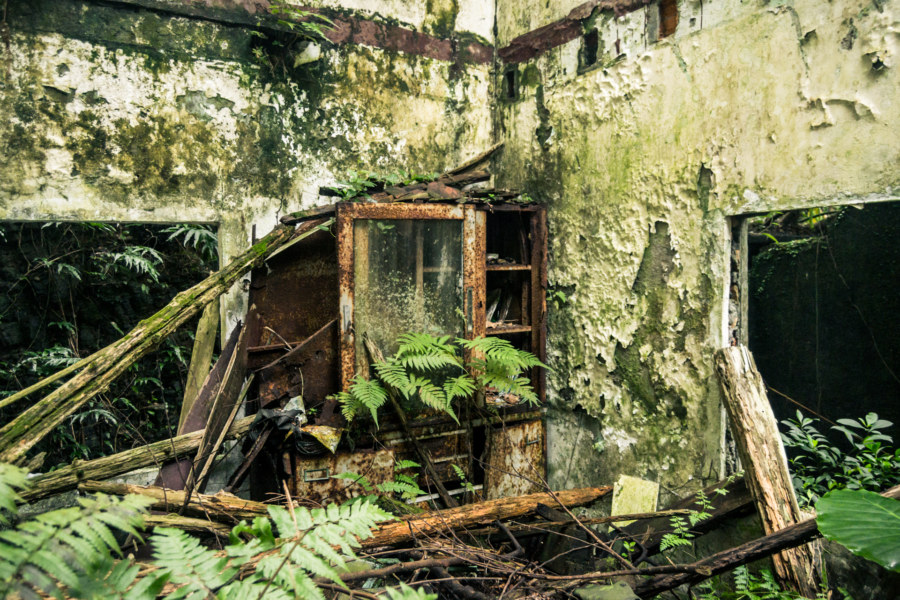
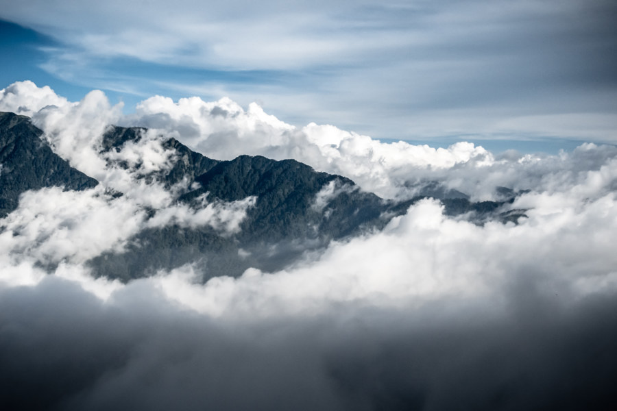
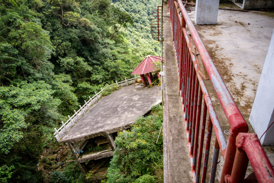
The ruins of the former Língxiāo Temple 凌霄殿 can be found in the foothills of the Central Mountain Range 中央山脈 in Puli, Nantou. Likely named after the Chinese trumpet creeper, Campsis grandiflora (中文), it was founded in 1983 by local philanthropist Chen Chou 陳綢, famous across Taiwan for her charity work. The temple is quite remote, more than 10 kilometers down an old forestry road with no other exit, perched on the hillside at an elevation of 1,300 meters (for reference, the Puli Basin 埔里盆地 is around 500 meters above sea level).

People’s Park in the Sky

A foggy People’s Park In The Sky

People’s Park In The Sky is a peculiar attraction located about 60 kilometers south of Manila in Tagaytay, a popular leisure destination in the province of Cavite in the Philippines. Perched on top of Mount Sungay at an elevation of 709 meters, the highest point on the northern rim of the immense Taal Caldera, it was originally planned to be a palace suitable for state visits during the kleptocratic reign of Ferdinand Marcos. Construction began in 1979 with a drastic leveling of the mountaintop, which previously reached 759 meters, but ground to a halt with increasing civic unrest and the cancellation of Ronald Reagan’s state visit in 1983. Following the People Power Revolution of 1986 the unfinished mansion was transformed into a public park and monument to the greed, corruption, and excess of the Marcos era.

Southern Taiwan Ride 2015: Dawu to Taitung City

Looking south from Taimali along the coastal highway in Taitung

My last big day of riding around southern Taiwan in June 2015 began in Dawu, Taitung, with only about 55 kilometers to go before arriving in Taitung City. I had been out in the sun far too much the previous day and was feeling rather sluggish and a bit sick so I didn’t end up taking any side trips into the mountains as I made my way north. Even so, the scenery was fantastic, and while I won’t have as much to write about this particular day of my trip, I have plenty of beautiful photographs to share.

Southern Taiwan Ride 2015: Manzhou to Dawu

On the road again in Manzhou Township

My fifth day of riding around southern Taiwan in June 2015 delivered me to the most remote parts of the island’s 1,139 kilometer-long coastline. On the previous day I rode from Fangliao, on the southwestern coast, around Hengchun and into the foothills of the Central Mountain Range 中央山脈 to reach Manzhou, one of the last places to find lodging before forging on to Taitung. I had already taken this route while riding all around Taiwan in 2013 so I was familiar with the territory, but that first tour was so rushed that I hadn’t been able to enjoy the scenery. (Actually, I had been outrunning a typhoon the last time I was here—but that’s a story not yet told on this blog.) This time around my intent was to take it slow and explore more of this obscure part of coastal Taiwan.

Southern Taiwan Ride 2015: Fangliao to Manzhou

Pebble beach vista in Fangshan

Last summer I embarked upon a weeklong bicycle tour in the deep south of Taiwan. I began in Tainan, cycled through Kaohsiung to Pingtung City, spent a day hanging out, and then continued on to Fangliao, where the coastal plain narrows to a thin wedge between the mountains and the sea. There is only one road leading south from here—which meant I covered a lot of ground I had already seen while riding all around Taiwan in 2013. I didn’t mind repeating that beautiful stretch of coastline and, actually, I was looking forward to checking out some places I had breezed by on that first big tour, particularly in Fangshan and Hengchun.

A Foggy Hike in Yangmingshan 陽明山

Coming down near Xiaoyoukeng

These photographs were taken in early October 2013 while hiking around Yángmíngshān National Park (陽明山國家公園). After meeting up with a friend we took a bus from Jiantan Station in Shilin to Lengshuikeng with the intention of checking out Milk Lake (Niúnǎichí 牛奶湖). Racing up the meandering mountainside roads we soon found ourselves immersed in an interminable fog. Debarking at the bus stop, with hardly another soul around, we decided to wander around and see what we could make of our time in Yangmingshan.

Ruchuan Village 入船里

Rewilding at the back of Ruchuan Village 入船里

Rùchuán Village 入船里 is a small community in Keelung, a historic port town of approximately 373,000 scattered among the rugged hills of northeastern Taiwan. Keelung’s growth over the last century has been constrained by a lack of flat land on which to build—with much of that concentrated at the foot of the harbour that now constitutes the downtown core. With few other options for expansion the city has sprawled upward along the hillsides and deep into the many valleys leading up from the port.

Crossing the Central Mountain Range of Taiwan 中央山脈機車之旅

Crossing the central mountain range of Taiwan

In the summer of 2014 I was nearing the end of my first sojourn in Taiwan. By the beginning of August I would be in Canada for a wedding in the family with no idea what I’d be doing after that. Since I wasn’t sure if I would be returning to Taiwan I made vague plans to go on a road trip. With only about a week to go before my departure the weather took an ominous turn as Typhoon Matmo 麥德姆 barrelled toward the island. On July 20th, with the pressure of time bearing down on us, my girlfriend and I hopped on a 125cc scooter—the same kind of dinky, puttering scooter you see people riding around any Taiwanese town—and set out from Changhua with the goal of crossing the Central Mountain Range 中央山脈 at Wǔlíng 武陵, the highest paved (and publicly-accessible) mountain pass in Taiwan at 3,275 meters above sea level. With luck, time and weather permitting, we’d be able to visit Héhuānshān 合歡山 and maybe even drive down into the amazingly scenic Taroko Gorge 太魯閣峽谷 on the east side of the island.

The Geographic Center of Taiwan 台灣地理中心

Centrality

The Geographic Center of Taiwan (台灣地理中心) is a modest roadside attraction at Hǔtóushān (虎頭山, literally “Tiger Head Mountain”) in Puli, Nantou, on the way to bigger attractions like Qingjing Farm (清境農場). As the name implies, it marks the geographic center of the island of Taiwan, albeit with a bit of a twist: there are actually two monuments here, one at the base of the mountain and another near the peak at 555 meters above sea level. It’s about a ten minute hike to get to the real center of Taiwan!

Ogon Shrine 黄金神社

Ōgon Shrine foundation

The Ōgon Shrine 黄金神社 (also known as the Gold Temple) is an abandoned Shinto shrine in the mountains above Jīnguāshí 金瓜石, an old gold mining town in Ruifang, Taiwan. Built in 1933 by the Nippon Mining Company while Taiwan was under Japanese rule, it was mostly destroyed in the post-war era by vandals. Even so, it’s in better shape than almost every other Shinto shrine in Taiwan apart from the Taoyuan Martyrs’ Shrine 桃園忠烈祠 and Kagi Shrine 嘉義神社 in Chiayi City. The incoming KMT government went to great lengths to expunge the island of Japanese influences.