Yeliu Signal Station 野柳信號臺

An Abandoned Signal Station in Wanli, Taiwan

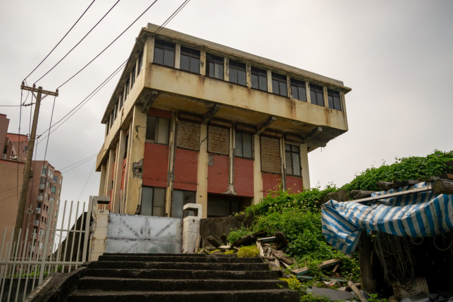
Green Bay is a forlorn stretch of sandy coastline in Wanli, a rural district of roughly 22,000 residents situated on the rugged northeastern coast of Taiwan. It is widely known for its many derelict resorts, most famously the so-called Wanli UFO Village (萬里飛碟屋), which is what initially drew me here in 2013. I returned a year later and noticed a dilapidated structure further along the beach, an unsightly institutional building similar in appearance to a Taiwanese police station of the 1980s. A closer inspection revealed an interior cluttered with intriguing artifacts and decaying documents—enough to conclusively identify this neglected ruin. This was formally known as the Yeliu Signal Station (野柳信號臺), an outpost responsible for monitoring maritime traffic in the shipping lanes and designated anchorages just west of the Port of Keelung.

Agenna Shipyard 阿根納造船廠

Overlooking Agenna Shipyard

Āgēnnà Shipyard 阿根納造船廠 is among the most popular abandoned places in northern Taiwan. It is located in the historic port city of Keelung across the narrow Bāchǐmén Channel 八尺門海峽 from Hépíng Island 和平島, site of the first Spanish settlement in Taiwan, and just around the corner from the equally photogenic Zhèngbīn Harbour 正濱漁港. The shipyard opened in 1967 but was only in business until the 1980s. After many years of neglect the skeletal ruins of the shipyard aroused renewed interest in 2016 when the current leaseholder attempted to demolish the structure. An immediate public outcry prompted the government to designate the shipyard a heritage property, and the cultural bureau is now formulating plans to develop the area into a tourist attraction of some kind. In the meantime, the crumbling ruins of the former shipyard attract hundreds or even thousands of daily visitors.

Postcards From Badouzi 八斗子明信片

Sundown over the coast of Badouzi

Near the end of my first summer in Taiwan I visited Bādǒuzi (八斗子), a rocky headland, coastal park, and major fishing port at the far eastern edge of Keelung. I went there on impulse, not knowing what to expect, just to see what was out there. Google Maps and Taiwan’s excellent public transit system make random explorations like this almost effortless: pick a point of interest and follow the directions—the digital equivalent of throwing a dart at a map. This post features a selection of retouched photos from this expedition alongside the sort of explanatory text I wouldn’t have been able to write back in 2013. Fair warning for arachnophobes: this post contains several gratuitous photos of giant spiders and other creepy crawlies!

Postcards From Nanfang’ao 南方澳明信片

Returning to Nanfangao harbour

Nánfāng’ào (南方澳) is a major fishing port in Su’ao, Yilan, on the east coast of Taiwan. It is located just south of the end of the Lányáng Plain (蘭陽平原), where a rocky headland juts out into the ocean to form a natural harbour. It opened in 1923 after development by the Japanese colonial authorities and is now considered one of the top fishing ports in the nation, often ranking in third place by measures unknown to me, and is particularly known for its record-breaking mackerel catch. Part of why the port is so productive has to do with the nutrient-rich Kuroshio Current (黑潮, literally “Black Stream”), which lies just offshore.

North Shore Road Trip

Allied Shipyard, North Shore

I met up with an old friend to hit the road in search of adventure today. And so we crossed the Ironworkers Memorial Bridge to the North Shore. We stopped in some random industrial area just off the Dollarton Highway then proceeded to Cates Park before entering Deep Cove. I figured it would be picturesque. Instead it was kind of dull and vaguely unwelcoming. We forged ahead to North Woodlands, which I only knew about from messing around with Google Maps. Turns out this remote community was even less welcoming than Deep Cove—virtually every vantage point was blocked by private homes. We snapped a few photos from the wharf and called it a day.