People’s Park in the Sky

A foggy People’s Park In The Sky

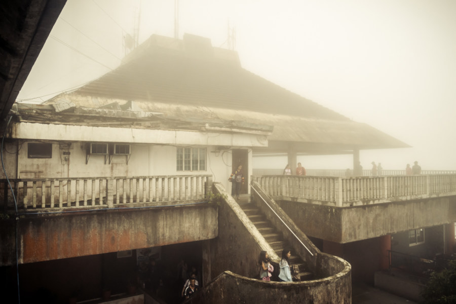
People’s Park In The Sky is a peculiar attraction located about 60 kilometers south of Manila in Tagaytay, a popular leisure destination in the province of Cavite in the Philippines. Perched on top of Mount Sungay at an elevation of 709 meters, the highest point on the northern rim of the immense Taal Caldera, it was originally planned to be a palace suitable for state visits during the kleptocratic reign of Ferdinand Marcos. Construction began in 1979 with a drastic leveling of the mountaintop, which previously reached 759 meters, but ground to a halt with increasing civic unrest and the cancellation of Ronald Reagan’s state visit in 1983. Following the People Power Revolution of 1986 the unfinished mansion was transformed into a public park and monument to the greed, corruption, and excess of the Marcos era.

Xiluo Bridge 西螺大橋

The North End of Xiluo Bridge

Xiluo Bridge (西螺大橋) spans the mighty Zhuóshuǐ River (濁水溪), the unofficial boundary between north and south Taiwan, connecting the counties of Changhua and Yunlin. Construction began in 1937 under Japanese colonial rule but came to a halt after the attack on Pearl Harbor as the allotted steel was needed for the war effort. In 1952 the bridge was completed under the incoming Chinese Nationalist government with American steel and financial aid. At 1,939 meters in length it was one of the longest bridges in the world when it was finished—second only to the Golden Gate Bridge at that time—and became such a source of national pride that it appeared on Taiwanese bank notes (specifically 第一套橫式新臺幣) and stamps in the 1960s. Originally it was equipped with sugar railway tracks but these have been removed and nowadays only light road traffic is permitted to cross the bridge.

Ershui Assembly Hall 二水公會堂

Out front at the Ershui Assembly Hall

Ershui Assembly Hall 二水公會堂 is located in Ershui, a small town at the very southern edge of Changhua, on the border with both Yunlin (to the south) and Nantou (to the east). It is one of approximately 70 assembly halls built all around Taiwan to accommodate large public gatherings during the Japanese colonial era. This particular example was built in 1930 and is one of three remaining in Changhua. The other two—in Changhua City and Lukang—are both fully restored heritage properties open to the public, but the smaller Ershui Assembly Hall has been derelict for years, a consequence of a long-running legal dispute between the landlord and local government complicating preservation efforts.

Postcards From Badouzi 八斗子明信片

Sundown over the coast of Badouzi

Near the end of my first summer in Taiwan I visited Bādǒuzi (八斗子), a rocky headland, coastal park, and major fishing port at the far eastern edge of Keelung. I went there on impulse, not knowing what to expect, just to see what was out there. Google Maps and Taiwan’s excellent public transit system make random explorations like this almost effortless: pick a point of interest and follow the directions—the digital equivalent of throwing a dart at a map. This post features a selection of retouched photos from this expedition alongside the sort of explanatory text I wouldn’t have been able to write back in 2013. Fair warning for arachnophobes: this post contains several gratuitous photos of giant spiders and other creepy crawlies!

Southern Taiwan Ride 2015: Taitung City

Looking northwest from Liyushan 鯉魚山 in Taitung City

Taitung City, the administrative capital of Taitung, was my final destination on a multi-day bicycle tour around southern Taiwan in the summer of 2015. Previously I shared words and photos from every day on the road so this post will act as something of an epilogue. Start at the beginning or read the last chapter to get up to speed—or treat this as a singular post about some of what I saw in an extra day of exploration around the most remote major city on the Taiwanese mainland.

Dadu Plateau Anti-Airborne Fortifications 大肚台地反空降堡

An abandoned fortification on the Dadu Plateau

Dàdù Plateau (大肚台地) is a geographic feature of great strategic importance to the defense of central Taiwan. It overlooks the Qīngshuǐ Coastal Plain (清水平原) and occupies high ground on the far edge of the Taichung Basin (台中盆地), home to the majority of the population of Taichung, the third most populous metropolitan area in the nation. The entire length of the plateau is peppered with military facilities from the massive Ching Chuan Kang Air Base (空軍清泉崗基地) in the north to Chénggōng Ridge (成功嶺) down south. In between one will find a number of abandoned or disused bunkers, gun towers, and blockhouses. This post focuses on seven anti-airborne fortifications located in the central part of the plateau starting with the #7 Anti-Airborne Fort (七號反空降堡), my introduction to this cluster of ruins.

Southern Taiwan Ride 2015: Dawu to Taitung City

Looking south from Taimali along the coastal highway in Taitung

My last big day of riding around southern Taiwan in June 2015 began in Dawu, Taitung, with only about 55 kilometers to go before arriving in Taitung City. I had been out in the sun far too much the previous day and was feeling rather sluggish and a bit sick so I didn’t end up taking any side trips into the mountains as I made my way north. Even so, the scenery was fantastic, and while I won’t have as much to write about this particular day of my trip, I have plenty of beautiful photographs to share.

Southern Taiwan Ride 2015: Manzhou to Dawu

On the road again in Manzhou Township

My fifth day of riding around southern Taiwan in June 2015 delivered me to the most remote parts of the island’s 1,139 kilometer-long coastline. On the previous day I rode from Fangliao, on the southwestern coast, around Hengchun and into the foothills of the Central Mountain Range 中央山脈 to reach Manzhou, one of the last places to find lodging before forging on to Taitung. I had already taken this route while riding all around Taiwan in 2013 so I was familiar with the territory, but that first tour was so rushed that I hadn’t been able to enjoy the scenery. (Actually, I had been outrunning a typhoon the last time I was here—but that’s a story not yet told on this blog.) This time around my intent was to take it slow and explore more of this obscure part of coastal Taiwan.

Southern Taiwan Ride 2015: Fangliao to Manzhou

Pebble beach vista in Fangshan

Last summer I embarked upon a weeklong bicycle tour in the deep south of Taiwan. I began in Tainan, cycled through Kaohsiung to Pingtung City, spent a day hanging out, and then continued on to Fangliao, where the coastal plain narrows to a thin wedge between the mountains and the sea. There is only one road leading south from here—which meant I covered a lot of ground I had already seen while riding all around Taiwan in 2013. I didn’t mind repeating that beautiful stretch of coastline and, actually, I was looking forward to checking out some places I had breezed by on that first big tour, particularly in Fangshan and Hengchun.

Southern Taiwan Ride 2015: Tainan to Pingtung City

A pink sanheyuan in Alian District

Bicycle touring is one of the best ways to experience Taiwan. I don’t have an opportunity to go touring as much as I’d like but managed to find some time last year, in June of 2015, to embark upon a multi-day bicycle trip around southern Taiwan. My intention was to cover some of the same territory that I had rushed through on my first bicycle trip down south in 2013. I ended up racing a typhoon from Kenting to Taitung City that year—so the chance to explore the backroads of Pingtung at a more relaxed pace really appealed to me. I started my journey in Tainan, my favourite city in Taiwan, and cycled through Kaohsiung to Pingtung City, putting about 70 kilometers behind me. Gathered here are some photos from the first day of this trip, continued here.