Explorations of the Pacific Edge 1

The easternmost tip of Taiwan

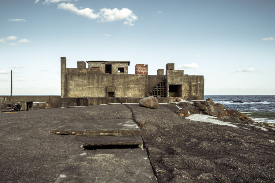
These photos were taken two years ago after cycling through the Old Caoling Tunnel 舊草嶺隧道 into Toucheng, Yilan. The first set of six photos were all shot along the rugged shoreline of the Láilái Geological Area 萊萊地質區 while the last four were captured at Mǎgǎng 馬崗, a half-abandoned fishing village on Cape San Diego 三貂角 (pinyin: Sāndiāojiǎo), the easternmost tip of Taiwan. All were captured in Gongliao. From here the vast Pacific Ocean stretches all the way to Baja California in Mexico.

Jiamuzi Bay Minsu 加母子灣民宿

Nothing left of the glass balconies except an extraordinary view

Jiāmǔzǐ Bay 加母子灣 is a beautifully remote and scenic stretch of coastline just north of Taitung City in Donghe, Taitung. It is also home to the gutted ruins of an abandoned mínsù 民宿 (a funky bed and breakfast or homestay-style inn) readily visible from just about anywhere along the bay. While cruising along the coastal highway on my first Taiwan bicycle tour in late 2013 I stopped two stops to take a closer look: once beneath the moody remnants of Typhoon Usagi and again on a sunny afternoon the following day.

Postcards From Nanfang’ao 南方澳明信片

Returning to Nanfangao harbour

Nánfāng’ào (南方澳) is a major fishing port in Su’ao, Yilan, on the east coast of Taiwan. It is located just south of the end of the Lányáng Plain (蘭陽平原), where a rocky headland juts out into the ocean to form a natural harbour. It opened in 1923 after development by the Japanese colonial authorities and is now considered one of the top fishing ports in the nation, often ranking in third place by measures unknown to me, and is particularly known for its record-breaking mackerel catch. Part of why the port is so productive has to do with the nutrient-rich Kuroshio Current (黑潮, literally “Black Stream”), which lies just offshore.

Crossing the Central Mountain Range of Taiwan 中央山脈機車之旅

Crossing the central mountain range of Taiwan

In the summer of 2014 I was nearing the end of my first sojourn in Taiwan. By the beginning of August I would be in Canada for a wedding in the family with no idea what I’d be doing after that. Since I wasn’t sure if I would be returning to Taiwan I made vague plans to go on a road trip. With only about a week to go before my departure the weather took an ominous turn as Typhoon Matmo 麥德姆 barrelled toward the island. On July 20th, with the pressure of time bearing down on us, my girlfriend and I hopped on a 125cc scooter—the same kind of dinky, puttering scooter you see people riding around any Taiwanese town—and set out from Changhua with the goal of crossing the Central Mountain Range 中央山脈 at Wǔlíng 武陵, the highest paved (and publicly-accessible) mountain pass in Taiwan at 3,275 meters above sea level. With luck, time and weather permitting, we’d be able to visit Héhuānshān 合歡山 and maybe even drive down into the amazingly scenic Taroko Gorge 太魯閣峽谷 on the east side of the island.

Asia Cement Aerial Tramway 亞泥空中纜車

A tramway tower in Hsinchu County

Yesterday I went out with a friend to explore several abandoned and neglected sites in Hsinchu, Taiwan. Our first stop was one of many mothballed cable car 空中纜車 towers in Guanxi connecting a stone quarry near Yùshān Village 玉山里 (formerly known as Chìkēshān 赤柯山) with a cement plant next to Jiǔzàntóu Station 九讚頭車站 in Hengshan. There seems to be no general agreement about the formal name for the system so I’m picking one of many options and dubbing this the Asia Cement Aerial Tramway 亞泥空中纜車 for the sake of simplicity.

Ogon Shrine 黄金神社

Ōgon Shrine foundation

The Ōgon Shrine 黄金神社 (also known as the Gold Temple) is an abandoned Shinto shrine in the mountains above Jīnguāshí 金瓜石, an old gold mining town in Ruifang, Taiwan. Built in 1933 by the Nippon Mining Company while Taiwan was under Japanese rule, it was mostly destroyed in the post-war era by vandals. Even so, it’s in better shape than almost every other Shinto shrine in Taiwan apart from the Taoyuan Martyrs’ Shrine 桃園忠烈祠 and Kagi Shrine 嘉義神社 in Chiayi City. The incoming KMT government went to great lengths to expunge the island of Japanese influences.

Postcards From Wenshan District 文山區明信片

Taipei from Xianyan temple in Wenshan district

Last year, near the end of 2013, I had the good fortune to move to Wenshan, the southernmost part of Taipei. In late September I was nearing the end of my first round-the-island bicycle tour and put a call out on Facebook asking if anyone knew of a place I could stay for a month or so. That call was answered—and I ended up staying with a couple of cool European guys for six months before heading south to Tainan in April 2014.

Nantou’s Misty Lotus Forest 忘憂森林

Misty lake, lotus forest

Collected here are a series of dreamlike photos from a road trip into the misty mountains of Lugu in Nantou, central Taiwan. I undertook this trip with a friend in July 2014. Our goal was the Lotus Forest 忘憂森林 (pinyin: Wàngyōu Sēnlín), also known as the Misty Forest 迷霧森林, a high mountain bog formed in the aftermath of the catastrophic 921 earthquake when a landslide altered drainage patterns, forming a small lake and drowning part of the existing forest. At an elevation somewhere close to 2,000 meters, the Lotus Forest is often shrouded in thick fog, imbuing it with an eerie mystique that attracts Taiwanese people from all over the island.